
Five Walking Tours of Oakland
The best way to experience and understand the meaningful history of Oakland is to take a walking tour. Garrett County, the youngest county in the state, has had Oakland as the county seat since 1872, but its history goes back much further. Its history goes back beyond George Washington, who came through here in 1754. He and many others searched for the portal that would allow expansion of trade to the Ohio River Valley. Garrett County has one of only three passages on the east coast that go through the Appalachians – the key for a growing country to opening the Ohio River valley. This made it ideal for finding many trails and, most importantly, the coming of the railroad. Not only did this allow commerce to increase, but it led to Oakland becoming one of the first mountain resorts in the US.
The five different walking tours below describe how Oakland grew in response to its role in the growth of the US. Each one features a slightly different perspective of Oakland, and each can be experienced either by itself or in combination with one or more of the others. So, put on your walking shoes and explore this small town with a deep history.
Download a copy of the tours, visit the online Google Map, or scroll down for all the tour details!
You can download a pdf version of the tours, print it out and follow along:
Oakland Walking Tours Printable Version
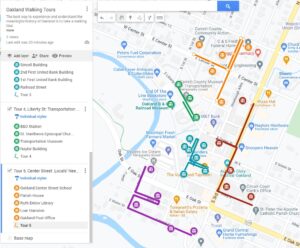
Visit our online custom Google Maps version of the tour. All of the content from the tour with online navigation and position.
Oakland Walking Tours – Online Google Map
The prinatable and Google Map versions of the tour both have images of each of the sites, most of them historical views of the buildings.
Tour 1 Third Street (Red Line) Government District
1A City Hall (15 S 3rd St)
In the 1950s, this used to be a gas station and later the home of the Oakland Equipment Co. The town purchased the building in 1993. With a new frame, new façade, new windows and a new entrance, it was transformed into this attractive building. The mural on the side of the building to your left, is by Roy Lichtenstein and commemorates the brave heroes who risk their lives in the name of public safety. Across the parking lot also to your left, is the site of where the Oakland Coca Cola Bottling plant once stood. It competed against the Orange Crush Bottling plant described later in another tour. When this plant closed in 1995, it was producing 600 cases a day.
1B B&O History Mural (Hinebaugh Alley and Green St.)
Retrace your steps to Third Street and to Green Street. About halfway between Second and Third Streets, on your left is a mural, by renowned and local artist Mark Stutzman. It is a montage of events that strongly impacted Oakland’s development. Most distinctive on this wall is the portrait of John W. Garrett, the president of the B&O railroad from 1858 to 1884. He is the person for whom this county is named. Also, you can’t fail to notice the picture of the Oakland Hotel, one of the first resort hotels built to encourage ridership by a railroad.
1C 1st Hospital (116 S 3rd St.)
This building is one of Oakland’s oldest having served several purposes over the years, and most importantly, as Oakland’s first hospital. While the building now is occupied by offices and an antique shop, since its beginning in 1859, it has had many uses such as a tin shop, cobblers’ shop, a hospital, clothing store, crafts, and law offices. On the second floor, on the Court House side of the building, is a porch that was designed for convalescing patients.
1D County Courthouse (313 S 3rd St.)
In the early 1900s, to meet growing demands of governance, a new courthouse was required. In October of 1907, a cornerstone laying celebrated this county’s new symbol of pride. It was proclaimed as “a temple of justice where the rich and poor, high and low will stand on equality and can be assured their rights will be preserved and wrong redressed as is possible to be done by human tribunals.” It has been remodeled several times, to make space for its growing responsibilities.
1E Jail and Sheriff’s Residence (203 S 4th St.)
A jail was built here at nearly the same time as the courthouse. The plans called for jail cells (including 2 for children and one for women) and an attached residence for the sheriff. Even into the 1960s it was not unusual for the Sherriff’s wife to prepare the meal for her family and fore the inmates, in their cells, of course. During the 1970s and ‘80s, the expansion of the Courthouse moved the sheriff’s office to a new wing, and the residence was eliminated.
Tour 2 Water Street (Purple Line) Beginnings District
This tour will guide you through the area of Oakland where it was in its infancy.
2A Geissman Hotel (319 S 3rd St.)
George Geissman operated a hotel here before 1900. It was a resort and often used by groups for meetings and workshops. It looked very different then. Imagine being a guest here as trains would go by blowing their horns for the Second Street crossing and spewing out all that smoke! Many changes to the siding and roof have been made since then. It now serves as an apartment building.
2B Salt Box House (205 E Water St.)
This is the last of these unusual homes in Oakland. There used to be several of these on this street. The name for the design, “saltbox”, comes from the shape of wooden boxes used to store salt. It is a type of frame house which is distinguished by having two stories in the front, one story in the back, usually with a huge chimney in the middle. The sloping roof encourages snow to melt more quickly in the sun while deflecting the strong winds common in this region. This is still a private home
2C Townshend House (100 S 1st St.)
Despite the updated siding, the bones of this building are still those of the oldest building in Oakland. In 1849 Oakland was laid out in a grid of 64 lots. This lot was designated as number 1. An 18” gray stone monument designates this as the starting corner of this nascent town. The 175-year-old stone is at the corner of Water and First Streets, in front of a large tree. This is still a private home.
2D Shirer’s Tin Shop
Until recently, this was the oldest continuously operating business in the county. In about 1873, Peter Shirer began smithing operations here. He became known for using the latest materials and technology and careful professional work that carried it through each of the next four generations of Shirers. This building is no longer in use, but it stands as a testimony to the early development and hard work that made Oakland unique.
2E Orange Crush Bottling Company (104 E Oak St.)
This building of several shops was once an Orange Crush Bottling facility. It began operation in 1939 as a modern facility that included a bottling room, a storage room and a syrup room! The processing equipment such as pumps and valves are still located outside the building along First Street. Mr. A. V. Schaeffer also sold soda drinks under the label “Shaef Garrett Soda.” A few of those soda bottles can be seen at the Garrett County Historical Society’s Museum. Despite the Orange Crush plant having begun production earlier than the Coca Cola Plant that had been on 3rd St., it ceased operations much earlier, bringing an end to the “Great Soda Wars!”
Tour 3 South Second Street (Blue Line) Commerce
On this tour you will see the heart of what is considered Oakland’s “downtown.”
3A Fireside Restaurant (119 S 2nd St.)
The first saloon here burned in the fire of 1898. Another saloon was soon rebuilt promising “private drinking parlors upstairs for those wishing privacy and those wishing pure whiskey for medicinal purposes.” In 1939 one of the businesses located here was a restaurant called “The Fireside.” It was built with a fireplace that was said to have been the largest in Maryland. Until the fire of 1994, other restaurants operated here. At that time, the fire weakened the timbers on the back of the building necessitating that it be razed. However, the stone fireplace lived on until 2003 when, for safety reasons, the chimney was shortened. However, the Sipside Tavern (sipsided.net) still features the now outdoor fireplace in the warmer months.
3B Offutt’s Big Store (115 S 2nd St.)
It is indeed a big store. It is the tallest commercial building still existing in Oakland. The original store had entrances on Railroad Street and Second Street, but it was burned in the fire of 1898. (During that fire, Mr. Offutt, then the store owner moved his salvaged merchandise, across the street to the Sincell Building and was opened for business the next day.) When the current building was built, all precautions to avoid damage from another fire were taken. This saved the Garrett National Bank building in a 1994 fire. In 1939, Mr. I. R. Rudy purchased the building and opened “Rudy’s.” Three generations have operated this store, the third generation, Mr. I. Robert Rudy, continues the tradition.
3C Garrett National Bank/GCHS (107 S 2nd St.)
This building has the longest history of any other in this commercial area of Oakland. Built in 1884, it has been modified and enlarged several times. In the 1970’s, bank operations moved diagonally across the intersection, and the space in this building was converted to offices. In 2007 the building became the home of the Garrett County Historical Society. They maintain an outstanding museum that wonderfully presents the history of Garrett County. The museum is open to the public. Best to check for special opportunities and hours of operation at info@garrettcountymuseums.com.
3D The Sincell Building (108 S 2nd St.)
As a young man, Mr. Harry Sincell grew up assisting in operations at the second Glades Hotel. In 1891, having grown up in an atmosphere of well-dressed people, he started his own business. Three years later he built this building for his clothing store on the first floor. He was joined by his brother, Benjamin who took over the second floor as editor, publisher, and printer of The Republican newspaper. Eventually, the third brother, Edward, hung his shield in an office in the back of the store. (Harry’s store was where Offutt brought his merchandise.) Until 2010, a pharmacy continued using the first floor and the newspaper operations continued until 2017. The ground floor is now occupied by the Garrett Arts Council and Gallery (garrettarts.org). Visitors are free to come in and browse the locally produced fine arts, most of which are available for purchase.
3E 2nd First United Bank Building (204 E Alder St.)
In 1903, First National Bank moved their operations from across Alder Street. As anticipated, this building became one of the most important locations for businesses and commercial interests. Even the Post Office operated here between 1910 and 1923. By 1963, the business grew, so a new building was built two blocks further up Second Street, across from the Post Office. This building here continues to be occupied by a variety of local stores and businesses. Browse around, you may find just “the right thing!”
3F 1st First United Bank Building (215 E Alder St.)
By 1900, the Garrett National Bank on Second Street had been in business for 16 years. Over the years, growth in the regional financial interests made it plain that there was a need for a second bank. Influential local leaders of the County’s economy established the First United Bank of Oakland. This building served as the bank’s temporary location while the new building was built. The building before you is the same one that was here 125 years ago. The building now houses the Vagabond taproom (vagabondtap.com) and the Shoefly Java coffee house (shooflyjava.com).
3G RR Street (S 2nd St & CSX Tracks)
Continue walking down the street to the Second Street crossing of the CSX tracks. Look to the right, up the tracks (away from the tunnel. Not too far away is the Fireside Restaurant, Rudy’s and the GCHS museum. At one time before a track realignment, there was a boardwalk between the tracks and the buildings. This was called Railroad Street. Many of the shops and restaurants on this boardwalk also had entrances on Second Street. Before there were dining cars on trains, at tis stop, passengers had to dash along the boardwalk to one of the dining spots to get a 20-minute meal before hurrying back to the train. With 12 trains a day stopping here, it must have been a very busy place.
Looking in the same direction but much closer to you, in the small triangle of land between the tracks and Second Street, is a 4’ white obelisk mile post. Such mileposts are still as important today as they were 150 years ago. The post gives absolute information for the distance to Baltimore with a “B” (232 miles) on the west side of the mile marker, and for those heading west towards Wheeling, the post shows a “W” on the east side (147 miles.)
Before there were such things as lights, bells and crossing gates, there were flagmen stationed at crossings with flags and lanterns to warn pedestrians, wagons, and automobiles of an approaching train. At this Second Street crossing there was such a crossing guard. In 1903 one of them was Larry Stanton. In the photo, notice a small shed next to the tracks. This provided shelter from the weather for Larry.
Tour 4 Liberty Street (Green Line) Transportation
This tour will show some of the sites that enabled the travel that fed Oakland’s growth.
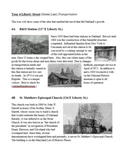
4A B&O Station (117 E Liberty St.)
Since 1850 there had been stations in Oakland. But not until 1884 was the construction of this beautiful structure completed. Influential families from New York to Cincinnati arrived at this station to be conveyed by a waiting carriage to one of the well-appointed hotels in the area. Once 12 trains a day stopped here. Also, this was where many of the goods for the towns shops and area farms were delivered. Due to changes in transportation needs and methods, passenger service at this station eventually ceased in April of 1971. In addition to this fine station are two cars and a 1920 locomotive with its tender. In 1974 it was put on the National Historic Register. This is a unique museum is open to all visitors. Best to check for hours of operation (oaklandbandmuseum.)
4B St. Matthews Episcopal Church (116 E Liberty St.)
This church was built in 1869 by John W. Garrett in honor of his brother, Henry S. Garrett, whose vision was to build a church that would celebrate the beauty of Oakland. Initially, it was referred to as the Stone Church. It was also known as “the church of the presidents” in recognition of Presidents Grant, Harrison, and Cleveland who had worshiped here. Since then, several denominations have worshipped here and presently, it serves St. Matthew’s Episcopal Church. The building is on the Maryland List of Historic Places.
4C Transportation Museum (108 E Liberty St.)
At the northeast corner of First and Liberty Streets is the Naylor Building. Around 1911, it This location, across from the Railroad station, has aways been devoted to transportation. Shops located here were livery stables, auto repair and auto dealers and now this museum, built in 2011. It has a treasure of various forms of transportation, many of which were used in this area. You can walk among vintage modes of transportation such as a carriage that conveyed visitors to the famous hotels, vintage automobiles, a jeep used in WWII and a high wheeler, and an early Oakland fire engine (info@garrettcountymuseums.com). Be sure to check hours of operation.
The Second floor of this museum is devoted to Deep Creek Lake. Time spent in this gallery is sure to make visitors to the lake say things like “Hey, I didn’t know they had that!” Behind the building is a small, but peaceful park with benches to reward a weary visitor. While seated, appreciate the wall of murals that are like a collection of post-cards commemorating life in different areas of this county. Leaving the museum through the front doors look to your right to see the large photograph on the exterior wall. It depicts Liberty Street in the 1940s. Now turn around to see that same setting as it is today. See any differences?
4D Naylor Building (Master Craft) (116 E Liberty St.)
At the northeast corner of First and Liberty Streets is the Naylor Building. Around 1911, it contained a dealer for Maxwell autos. The next year, a very high wind blew the roof off the third floor. It was never replaced, leaving it as a two-story building. Then in February 1926, again, fate struck the building when a fire caused considerable damage. Occupants on the second floor were rescued from the building, still dressed only in their nightclothes. The outside temperature was 9 degrees! There’s still more! In February 2008, for no apparent reason, the front wall of the second floor collapsed – over a period of four hours while onlookers watched. Today, the second floor has been rebuilt and Master Craft printers are located here.
Tour 5 Center Street (Silver Line) Locals Needs
This tour guides you around those sites that met the need of the community’s residents.
5A Oakland Center Street School (104 E Center St.)
This fine-looking building was built in 1895. At that time the fall school term lasted only six weeks. By 1901, 300 students were enrolled here and by 1910, the school had become so overcrowded that high school students were moved to another facility. In 1922, fire damaged the second floor and bell tower, requiring all classes to be held at other buildings around town until repairs could be made. Unfortunately, the bell tower was never fully repaired. Currently, the building has been repurposed as a Senior Center, apartments, and other uses.
5B Parish House (121 E Center St.)
In 1935, this building was the parish hall for the Episcopal Church that was using the Old Stone Church. When they vacated it, it briefly housed the local unit of the Maryland National Guard. Following that, funds were raised by many local organizations and in 1961, the first Garrett County Historical Society Museum was opened. By 1997 they needed a larger space so they moved to their present location. After that, the Our Town Theater group purchased the building, and it continues to entertain residents and visitors alike (ourtowntheater.org).
5C Ruth Enlow Library (6 N 2nd St.)
In 1915 the first truly public library began limited operation in local buildings. Finally, in 1946 an accredited librarian assumed responsibility for the library. At that time the library’s collection of books numbered only 2,534. Finally, donations made it possible to purchase this property. Additional funding for construction of the library was donated by a Mr. Enlow. And, in 1950, the dream of a county library was realized. The library system now includes four other branches throughout the county with thousands of books and all of the modern equipment available in much larger library systems (facebook.com/RuthEnlowLibrary).
5D Loar Mansion (21 N 2nd St.)
This Colonial Revival yellow brick building was built in 1900 by the Loar family. They had been associated with life in Western Maryland since 1780, and by 1869, an early ancestor had built a general store here. The last Loar, a wealthy merchant, built his home here. Unfortunately, in 1946, Mr. Loar became an invalid. Because of this, he recognized the need for a county hospital and made a generous donation for the construction of the one. There are no longer any descendants of this kind and generous family. This building now serves as a funeral home.
5E Post Office (22 S 2nd St.)
The earliest post office, starting in about 1812, was in the nearby settlement called Yough Glades. Since 1854, Oakland has had many post offices. As part of a program to return Americans to work during the Great Depression, $80,000 was set aside for the construction of this Post Office. Features of this building includes tall windows with distinctive grill work, and a polygonal cupola that designated this as an important Federal building. Often overlooked is a large bas relief figure of an eagle above the door as shown in the Architect’s drawing. When opened in 1939, the first postmaster was I. R. Rudy.
Inside, this building remains much as it was when it was built including a mural entitled “Buckwheat Harvest.” In 1933, again to aid in the recovery from the depression, the Federal Government selected artists to produce murals in Federal buildings. This Post Office was selected to be one of the only 1037 Post Offices that was chosen for one. The noted artist Robert Gates was chosen to paint the mural that is displayed high on the wall as you enter the lobby. It is entitled “Buckwheat Harvest” in recognition of the grain that was vital in Appalachia during the Depression.
These tours were created by John MacGowan for the GCHS.
We hope that you’ve enjoyed your personally conducted tour. For years, others have enjoyed being here as well. Take, for example, what John McHenry had to say. John was the son of James McHenry for whom Ft. McHenry is named. His family had a home on Alder between Sixth and Seventh Streets. In a letter to his cousin, John wrote:
Baltimore, 12/22/1820
I know of no country better suited than this for such a change – a country not obnoxious to the unwholesome damps & vapors, of thick forests – river bottoms but a continued suite of Glades with a perspective through groves of white oak from one glade to another, each presenting a variety of prospect of hills and valleys, and thro’ each valley flows a stream of pure spring water in a deep, narrow channel, which the freshness of the air thro’ summer season always keeps cool. A country almost unoccupied, no peculiar customs, prejudices or manners that a new settler is obliged to accommodate himself to except treating the original settlers with kindness and civility, which will be reciprocated and received without the rude forwardness so common among the under classes in other quarters.
You can download a pdf version of the tour to print out and follow:
Oakland Walking Tour
Visit our custom Google Map with all the content of the walking tour with navigation and directions. Oakland Walking Tour Online Google Map